12/13/2017
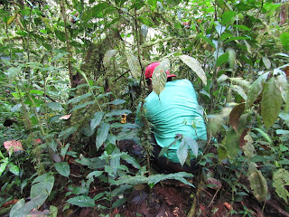
Today was the first day we got to set up our instruments for the project! We first met at the lab to go over the game plan and to pick up our lunches. We decided that we would chose three locations on an elevational gradient (high elevation, mid elevation, and low elevation). Our first site was the closest to camp and the highest elevation, and there we chose three plants of chamadorea species to sample. we decided to sample the eight branch down the spiral and the second leaflet on the branch. We then took photos of the sample to analyze on imageJ in the very near future. Additionally we set up the kestrels to record wind speed, temperature, and elevation. Additionally, we recorded the exact elevation and GPS coordinates. We continued this process for all three sites. We then ate lunch by the river and then ventured into the primary forest. To say the least, i was in awe while in the primary forest!!! See the attached photos because my descriptions never do justice!


Today was the first day we got to set up our instruments for the project! We first met at the lab to go over the game plan and to pick up our lunches. We decided that we would chose three locations on an elevational gradient (high elevation, mid elevation, and low elevation). Our first site was the closest to camp and the highest elevation, and there we chose three plants of chamadorea species to sample. we decided to sample the eight branch down the spiral and the second leaflet on the branch. We then took photos of the sample to analyze on imageJ in the very near future. Additionally we set up the kestrels to record wind speed, temperature, and elevation. Additionally, we recorded the exact elevation and GPS coordinates. We continued this process for all three sites. We then ate lunch by the river and then ventured into the primary forest. To say the least, i was in awe while in the primary forest!!! See the attached photos because my descriptions never do justice!
 |
| Site 1-high elevation plant 1 |
 |
| Site 1-High elevation Plant 3 |
 |
| Site 1-High elevation plant 2 |


Comments
Post a Comment